


First let me introduce myself. I'm a nature photographer. I often go where no cell service has gone before. As such I have two important needs. I must know where I am and how to get where I wish to be. My other need is to communicate with the outside world for safety and more routine issues. The inReach, since its inception at DeLorme has filled the second need by providing a reliable two-way satellite texting device. I've had each model and they all worked perfectly... period. My first need, orienteering was achieved over the years by a succession of GPS devices from Garmin. Each was a leap forward from its predecessor and also worked as advertised. Of course, I'm no fool so there's a magnetic compass and map tucked in a pocket of my backpack in case of electronic failure.
OK, now for the review. In 2016 Garmin bought DeLorme. A year later we see the inReach Explorer+ which merges both the inReach satellite communicator with an on-board GPS including 24K scale maps of the US and Canada (Mexico is also included, but at less resolution). So let's consider what that means. In a single device you have the ability to accurately locate yourself on a topo map, move to any other location on the map and drop a waypoint and the inReach will draw a straight line route to follow via the map or the built in compass. All the while you are aware of the terrain over which you must travel. You can adjust as needed to avoid obstacles by dropping additional waypoints. But wait... there's more. you also have the ability to send and receive MESSAGES to anyone (not just other inReach users) via text (SMS) on their smartphones or email. So you're never alone. You're also one button away from an international search and rescue service which will SEND HELP at once while staying in communication with you. All messages sent from the inReach, both routine and SOS include your exact location. The recipient can click on a link and see exactly where you are on a topo map. So BOTH of my basic needs are met with just this one device.
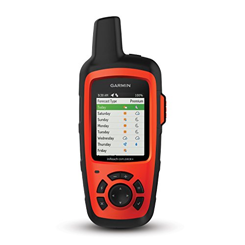
THE FUNDIMENTALS: Now for the big questions: Does it work? Do I need it? Is there something better for me? YES IT WORKS. The satellite communicator on this newest model works as reliably as the older versions. In other words, if you can find some sky. it will get your messages out and responses back. The time it takes depends on how much sky you can see and how often you set it to look for satellites. As for the new GPS features, they are also reliable as you would expect coming from Garmin. The screen on the InReach is a bit smaller than top of the line dedicated GPS devices. The user interface is not touchscreen and the map isn't as ultra bright as newer units, but it works fine in bright sunlight. That's on purpose. Unlike simple GPS units that only receive signals from orbiting GPS satellites, the InReach battery is designed to also send messages to a different group of communication satellites from Iridium located miles in space and still last at least 100 hours in the backcountry when set to its default of checking for satellites every ten minutes. To achieve these goals the battery can't support ultra bright or touch screens. But I have found that by cupping my hand over the screen I can read the finest detail at high noon on a sunny day. The topo maps are fully detailed with altitude rings clearly marked and showing the type of terrain. Even some stores and business names are given in the towns. So to be clear, this is a robust, reliable satellite communicator and GPS orienteering device all in one package with the ability to last 100 hours on a charge if used responsibly. I have had my InReach last well over a month by lowering the screen brightness when not in the direct sun, turning it off at night and contacting friends and family only three times a day at prearranged times to minimize when the InReach needs to seek satellites. Using a hand compass once the InReach gives me my fix lets me turn it off for more battery life. Then I only turn on the InReach when I need to confirm my location. In my thinking, everyone who drives out of cell coverage should have one of these with a minimum subscription plan if only to be able to summon help if the car brakes down. Remember you can buy brighter touchscreen GPS units that receive both US and Russian GPS satellites. But not one of them will summon help or let you keep in touch with family and friends. So buy the InReach for its communication abilities and consider the GPS features a welcome bonus. By contrast a satellite phone will cost over $1000 and the monthly costs are at least ten times more than the InReach. And satellite phones don't have maps, compasses, and accurate GPS location.
THE COST: What will it cost me? Unlike a simple GPS device that you buy once and then use for years, the InReach is also a satellite communicator that lets you send and receive messages and contact Search & Rescue in an emergency. This is what sets the InReach apart. DON'T COMPARE it to any other GPS unit. That's like apples vs oranges. No other GPS unit will communicate. So don't buy the InReach if you don't want or need the satellite communication features. You will be wasting your money. But if you're like me and are glad that a device exists to allow messages from the trail when there is no cell service the InReach is for you. Here's what to expect for cost. First you buy the InReach itself. Then you have to activate it which is done online to record your information and subscribe to the Iridium Satellite and GEOS Search & Rescue services. Like any utility, they cost. Garmin doesn't provide the satellites or the SOS service. They just activate you with Iridium and GEOS. Both of these activations cost Garmin and that cost is passed on to you. So just by activating your InReach you will be charged for these activation service fees which must be renewed yearly. Then you need to choose a subscription plan. These are a set of options that let you choose how you wish to use the InReach. I like an Annual subscription so the InReach is always active. I keep it in my car in case of a breakdown outside of cell service to summon road services and notify family. Some will choose a "Freedom" plan which lets you activate and deactivate the InReach on a monthly basis. This saves monthly charges that an annual plan would have for when you don't use the InReach. But if your InReach is deactivated with the Freedam plan you must reactivate it BEFORE taking it on a hike. When not active the Iridium satellites will not accept any messages from the InReach. This includes a message to a friend to reactivate it. To sum up the cost please realize that the InReach is PRIMARILY a satellite commicator that uses a service that has both an annual and monthly charge. So do yourself a big favor and throughly read the subscription page on the Garmin website to understand these costs before you buy the InReach. You don't want any surprises later. I'll be a bit subjective here and simply say that it costs me less than $15 each month to have the InReach always available. That's less than I pay for my morning coffee and pastry at the local shop for just one day. I think it's a very cheap price to pay for something that can save your life, keep family and friends updated on your hiking or boating progress and let you keep in touch from anywhere on Earth. The fact is that there is no other device available that provides two-way satellite communication so inexpensively. In fact nothing else comes remotely close. The InReach opens up the normally expensive world of satellite communication to everyone. Remember you can have full-time active service with search and rescue support each month for less the you pay for one day's morning coffee stop.
THE KNOWN BUGS: Now for the bugs part. Everything that I have already discussed works perfectly and bug free to my knowledge. But the inReach has some other features that are'nt needed for communication and orienteering, but make it easier to get some things done. It can connect via Bluetooth to your smartphone or tablet. Then you can have a larger screen and easy keyboard to view the map and send a text home. It also has a website assigned to you alone to set waypoints, create routes, overlay additional types of maps, list your frequent contacts, and often used text messages. These are not necessary features, but using them before setting out will make your time in the back country easier. This is where the bugs are showing up. I've read that syncing with a MAC to download routes, contacts, pre-written messages etc. is having problems. In my experiance, connecting via Bluetooth to my older iPhone using pre iOS 10 software is a problem with the app provided. What I can say with certainty is that the people at Garmin, many who stayed on when it was taken over from DeLorme are dedicated. I have faith that these bugs will soon be fixed with a new firmware update. In the meantime, the problems don't impact the stand-alone functionality of the inReach Explorer+ so as to be a deal killer. There is NO OTHER OPTION if you want both GPS and two-way satellite communication. If you don't go off the paved roads and don't need the GPS features, you might consider the inReachSE at $50 less or the new InReach Mini at $100 less (with half the battery life and a much smaller screen). So don't hesitate to buy this great device. As a stand-alone unit it works perfectly. There is no substitute. The bugs are related to unnecessary, but useful features. Think of it this way. This can save your life if you're lost in the wilderness, at sea, or just in a ditch along the Interstate out of cell phone range.
UPDATE 3/31/17 - I received a response from Garmin tech support. Unfortunately they have discovered that the inReach Explorer+ (and presumably the SE+) will not communicate with the EarthMate app on iOS devices older than iOS 10. The issue is that the new inReach uses a more advanced Bluetooth protocol. The older Apple devices can't interface with the new hardware in a way that EarthMate needs. So if you have an iPhone 4s or any iPhone or iPad that uses the older wide connector, you're out of luck. BUT TAKE HEART. All is not lost, by any means. EarthMate still runs on the older iPhone which has its own GPS, compass and accelerometer. So even though the inReach is not talking with EarthMate, you still see the same maps, same exact location and direction of travel on the EarthMate app on the phone. EarthMate is just using the iPhone's hardware instead of the inReach. So only two features are lost when the Explorer+ can't connect to an IPhone. The first is the loss of a bigger, and easier to use keyboard, although with a little practice, using the inReach keyboard can be quite fast. The second is the ability to Sync the inReach on the trail with the Garmin site via a phone or tablet if you have cell or WiFi service. This shouldn't be an issue for most people with a computer and WiFi since Syncing is only done after changing your pre-written messages or adding contacts. Most people will do those tasks at home and them Sync with a USB cable.
I did discover that the InReach will send waypoints created on it to the Garmin site when it gets satellite connectivity at no cost to the user. So family and friends who are following your trip via the Garmin Mapshare site will see your new Weypoints as you create them. The ability for EarthMate on the iPhone to download maps not built into the Explorer+ is still available via cell or WiFi even if it can't connect to the inReach. Map downloads always use the Internet not the satellite system because of their large size. Additional North American maps always reside on the phone, not the InReach. Nothing different here. So users like myself can still get aerial photo maps, NOAA charts etc. and since both devices have GPS there is no difference if the inReach and phone can, or can't connect. So we're back to the fact that the ONLY loss if you have an older iPhone is a larger keyboard and Syncing on the trail. No big deal.
To me, the InReach Explorer+ as a stand alone device is a major breakthrough because it includes a 24k background topo map. Now the always reliable inReach communicator is also a true GPS locator and orienteering device. The fact that it's 100 hour battery will also outlast any phone many times over just seals the deal. So connectivity to a phone or tablet is really outside the primary features set of this device which are satellite communication and GPS location and orienteering with 24k map display. The added advantages of connecting to a phone are at best in the convenience category and after the phone's battery dies, are of no value.
I'll make it a simple decision... If you are day tripping and not leaving the cell network, but want detailed maps with waypoints, routes, and an easy to follow compass. Leave the inReach at home and just use the EarthMate app on your older iPhone. If you need to communicate with someone, use the phone. However, if you think that you may stray beyond the cell network, the inReach is the ONLY reliable way to communicate with family and friends who may help to summon auto club services, police, or ambulance. And even without a phone connection it will lead you safely out of the woods. For under $15 a month that's quite a bargain.
TEXT vs EMAIL: The InReach must use local Cellular services to get texts to a recipient's phone. These independent cell companies are not always reliable with texts which can overwhelm their servers. If you have problems with texts reaching their destination JUST USE EMAIL and skip the buggy cell service. Garmin is always working with cell companies to fix issues but it's not in their direct control. So just send emails instead of texts.
ACTIVATION: The InReach won't work right out of the box. Because it is a communication service, it needs activation with the Iridium satellite network, GEOS search and rescue coordination service, and a user profile established at Garmin that holds information vital for use in an emergency, and finally getting your online settings page and MapShare page setup the way you like. The Activation process will first add your InReach to the system and then record routine billing, demographic, and emergency contact info. Once that is done you can use the InReach. Later you can get online and add your routes, Weypoints, contacts, quick message text and recipients, and much more.
Activation has been easy and successful for most users. However occationally problems pop up that make it difficult to complete the required activation and therefor stop the InReach from going into service. However, if this happens to you contact Garmin Support at once. Don't try to figure out how to fix the problem yourself. Activation requires a complex process that must happen in a precise order or it won't continue. Only Garmin support is able to intervene successfully. With that understanding the wise user will activate and test the InReach well before going on an off-grid adventure. Setting it up the night before you depart gives you no time to correct problems especially since Garmin support is only available on weekdays. The good news is that once activation is complete the InReach will work flawlessly for years to come without ever having to reactivate. It's reliability is well documented by its high user review scores at Amazon, REI, and other suppliers.
CUSTOMER SERVICE: Now just a few words about customer service from Garmin. When the InReach was designed and sold by DeLorme, a small company in Maine with a long reputation for excellent mapping services the customer service was excellent. They had a dedicated staff devoted exclusively to the InReach. They really were experts on every facet of its use, activation, and subscription options. I had many great chats with these DeLorme employees and have great respect for them. Many continued working for Garmin after DeLorme was acquired. Some reviews on Amazon express frustration with the current customer service from Garmin. I can't directly speak from experiance about Garmin InReach support since I have become a bit of an expert myself over the years and don't need to call them. But it occurs to me that the Garmin customer support team must have to take calls about dozens of devices from this very large company. So it seems reasonable to me that they may not be as knowledgeable as the DeLorme support staff about the many unique facts of the InReach. If you need to call customer support be patient. If they haven't solved your problem or answered your question clearly ask if they can email you additional fact sheets on your problem. If needed, ask to speak to a supervisor who may be more knowledgable. Don't give up. The hardest part of the InReach is getting it activated and working. Once you do that the rest is easy and automatic. Keep in mind that there are THOUSANDS of perfectly working InReach units throughout the World. If you are having problems I'm sure there is a simple solution such as reducing the time that it looks for satellites to avoid missing them as they fly by. Keep calling customer support until your issue is resolved. But don't give up on the InReach. It is too valuable for your safety to abandon just because you haven't found the customer service agent with the information you need. I'm sure that as time goes by more and more Garmin customer service agents will be become more knowledgeable on all of the complex aspects of the InReach. Also understand the customer service is not open on weekends or after normal business hours. So plan ahead and activate and test your InReach when customer service is there to provide help if needed. Above all, don't be foolish and activate the InReach on a Friday night before heading out on a week in the wilderness. Understand and accept what is, not what you would prefer. Garmin does not provide full-time customer support. It would be nice if they did, but as of now that isn't the way it is. If you have issues on that Friday night put the blame where it belongs,,, on your poor planning.
INREACH MINI: UPDATE 8/19/18 - Garmin has just announced the Inreach Mini, a much smaller version of the InReach SE+. The Mini comes in orange or black cases, is about half the size and weight of the SE+. Note despite the orange option which in the past has been reserved for the InReach Explorer+, the InReach Mini has no GPS navigation or mapping built in. Like the InReach SE+ the Mini must pair with a smartphone to use the Earthmate app and provide these navigation features. Having tested the MINI against the Explorer+ and compared the specs with the other InReach models I can make a few observations that might be helpful for those trying to decide which version is best for them. Of prime importance is the fact that the InReach Mini provides all the functionality of the InReach SE+. Full two-way satellite communication with all the existing perks like tracking, MapShare and social media interface, Bluetooth connectivity to a smartphone for navigation etc. The Mini has added connectivity to certain Garmin devices like their watches to be able to control the Mini from the watch or other Garmin device. Here are a few pros and cons that I feel may help a buyer decide which InReach best suits their needs. PROS: Small size and weight. This wil be welcomed by multi-day hikers who must be obsessed with the total weight that they must carry. It also lets you drop it into a backpack side pocket or other small space. Full InReach functionality. The Mini will do everything that it's bigger brother, the InReach SE+ will do. Ability to connect to certain Garmin devices. For off-grid adventurers, such as trail bikers who use Garmin watches this makes it easy to control the Mini from the watch. CONS: The screen is much smaller than the InReach SE+ making it a bit less convenient to move to options such as messaging, or compass. The ability to type a message is significantly harder than the InReach SE+ with its full on-screen keyboard. The InReach Mini lines up the alphabet vertically along the right side of the screen. The user must then scroll through letter by letter selecting those to use for the message. On the InReach SE+ movement around the keyboard is able to skip unwanted letters thus making writing a message much faster. Battery life has been cut in half from 100 hours on the InReach SE+ under normal use to 50 hours on he Mini. For the day hiker or casual adventurer that is no problem. And the battery life can be greatly extended by going into a power conservation mode. But for the long trail hikers and multi-day hunters as well as boaters on long trips offshore the extra battery life of the InReach SE+ could be critical. Especially since wise practice requires conservation for emergency use to coordinate with search and rescue. Since the InReach Mini is priced only $50 less than the InReach SE+ the multi-day hiker or boater would be well advised to spend the extra money to get double the battery capacity. Garmin has cut some corners to make the MINI half the size and weight of the SE+ and Explorer+. These omissions are of no significant consequence. I have written a full evaluation of the InReach MINI and its many changes. Please look under the MINI's page on Amazon. The bottom line is that I gave it only four stars and feel it doesn't meet the reliability found in the larger models.
CHOOSING THE RIGHT INREACH FOR YOU: I know that choosing an InReach involves a lot of information to consider. It can easily get confusing. Here are the main differences and examples of how to choose the one for you. The InReach Explorer+ priced at $449 is the top of the line with both satellite communications and a well designed and accurate GPS navigation system including high resolution maps of North America built in. It's strong point is that it has all you need in a single unit with 100 plus hours of battery life. The next step down is the InReach SE+ which has all the communication features of the Explorer+ but without the GPS navigation system and maps built in. It costs $399. Finally there is the new InReach Mini with all of the communication features of the SE+ and Explorer+ but, like the SE+ lacks GPS navigation within the unit. It is much smaller and lighter, has only a 50 hour battery life, and it's screen is much smaller than the larger InReach models. It sells for $349. Choosing which model is best for you depends on your expected activities. First, let me stress that since the price differance between the top and bottom of the line is only $100 anyone considering an InReach would be wise to think of spending the extra money for the Explorer+ since you never know when having a map and precise location built in can be lifesaving in itself. That aside, here are the circumstances where each excels. The Explorer+ is the best choice for the overnight off-grid hiker, offshore boater, or adventurer. Some will be tempted to choose the Mini for its light weight. But then any navigation will require linking it to your smartphone and using the EarthMate app. The problem is that smartphones have no chance of nearing the battery life of the InReach and any saving in weight will be countered by the weight of carrying the phone. When the phone dies, so does your GPS navigation. That's what makes the Explorer+ so groundbreaking a device. Everything is built into one unit with long and lasting power. For those who never go hiking, hunting, or offshore boating they may prefer the savings and forgo built-in GPS navigation. Then the choice is between the SE+ and the Mini. The only new feature that is unique to the Mini is its ability to connect to some Garmin sport watches. If weight and size are a big concern to you, the Mini has you covered. If double the battery life and a bigger and easier to use screen mean a lot, get the SE+. As for me, I consider any InReach of equal value as a satellite communicator. They all will send and receive messages, activate an SOS to GEOS for Search and Rescue or just if you breakdown on the road in a place without cell service. They all will pair with your smartphone running the included free Earthmate app for easier typing on your phone and a larger screen to view the messages and map. It's important to understand that all three InReach models will provide the same high quality GPS navigation if they are linked to your phone and running EarthMate. So if you choose the SE+ or Mini both will still provide great GPS location on a map with a built-in compass if you link them to your phone and use the EarthMate app. This will serve the day hiker well as long as the phone's battery holds out. Some users have reported problems linking the InReach with the newest phones. Garmin should catch up with future firmware updates. As for satellite communications, all models work the same, have all the same features and reliability, and cost the same for your choice of subscription.
OBSERVATION OF CONSUMER REVIEWS - PLEASE READ THIS
I have been reading various reviews by many people and I've realized that consumer reviews have an inherent problem. They are subjective and limited to the assumptions of the consumer. So I would like to make some observations to help perspective buyers make a good decision.
Reviews should be made by people who have tested the product for its intended use. There are lots of "I just got this today. I'm thrilled" reviews. They are worthless. They only tell us that the customer is excited by what they read in the advertising and no more. They haven't tested to see it it works as advertised. Then there are the "My salesman told me it would do this, but you need a subscription. What a scam." reviews. Sales staff get it wrong sometimes. If you want good information read the manufacture's web site. Call technical support. For Goodness sake ask an expert, not someone who has a bone to pick with a sales agent. Then there are the angry fringe flat Earth people who need to shout from the rooftops that everyone is lying to us and the sky is falling. Although I like to keep an open mind, I have little use for someone who always complains and never suggests a solution. My time is to valuable to listen to negative babble with no desire to seek a better approach. Finally, please understand what the main function of a product is. Are there other products that provide the same function? Can I buy it and get a refund if I'm not satisfied in a reasonable time?
As for the inReach, its MAIN function is two-way satillite communications and SOS rescue access. That is a service, like your phone, cell, gas, electricity, or cable at home. It costs each month for these services. You understand that. Why pay attention to a reviewer who is upset if a communication service like inReach expects to be paid and will cut off service after reasonable attempts to contact you if it isn't? When you first setup a new InReach Garmin must open a subscription for you with the Iridium satellite network. This costs Garmin and commits you to a full month of service. If you change your mind and return the InReach and expect a refund only the cost of the InReach can be returned to you, The satellite service has already been paid for with your expressed permission by setting it up and Garmin can't get a refund from Iridium. Consumers who don't take the time to read and understand what they are buying should not complain later when reality sets in. The InReach isn't a self-contained walkie-talkie. It's more like a phone that uses a sophisticated service to send your messages across the World. If you return a phone you don't expect a refund for the service used.
The inReach also has GPS location and tracking features. But these are NOT its main purpose. There are great GPS units available that are cheaper and have more GPS features... but they won't communicate from the backcountry. The InReach can't pack all of the latest features found in more specialized GPS devices into one small unit without sacrificing battery life or power, not to mention the cost increase. If you're not going to communicate, don't buy the inReach. If you don't need GPS navigation get the InReach SE+ or MINI at a lower cost. If you need special features like deep ocean charts, a card slot, or both US and Russian GPS access get the SE+ along with another Garmin GPS unit designed for that purpose. Please consider your circumstances first. Do you need the peace of mind that the inReach offers? If you are hiking, injured and otherwise lost to the outside world would you be satisfied with a PLB (Personal Location Beacon) that will notify authorities of your location but not of your specific injuries, medications, medical conditions and other factors that may be crucial for first responders to understand. The inReach is the ONLY way to have a two-way conversation with rescue services unless you wish to pay thousands of dollars for a satillite phone. Remember all devices won't be perfect for every user. To paraphrase the Rolling Stones... You don't always get what you want, but with the full range of great Garmin options you CAN get what you need. You just may need two devices.
PLEASE take what you read here and in other consumer reviews with a grain of salt. Is it a true review, or just a person bragging about their newest toy? Is the review relevant to your requirements? Did you ask the experts by reading advertising from the manufacturer, downloading the manual, or calling technical support? Consumer reviews are nice, but they have their limits. Be a wise consumer and do your homework. Thanks for reading my observation.
If you need the ability to summon help or text from anywhere, get this device. I’ve used in multiple countries with no issues. I often ride an ATV in the back country, and having the ability to let my wife know I’m ok and going to be late is great. I also liked the idea that I could use the SOS feature to summon help if needed. I seem to have a tendency to get myself into “situations.” I always wondered what exactly would happen if the SOS button was pressed. 2 months in to owning this device, I found out. While riding with no cell coverage, I came across another ATV rider who was having a heart attack in the middle of the trail. Miles from cell coverage, I reached out and pressed the SOS. Within a minute, the emergency operator was texting me that my SOS had been received. I was able to communicate the nature of the emergency to the dispatcher and receive confirmation that help was in route. Knowing that help was on the way puts your mind at ease vs a SPOT, where you have no clue if your distress signal has been received. Within 20 mins, police, firefighters, ambulance and fish and wildlife were on the scene. As was my wife, as I had neglected to text her that I was ok, and she was the 1st emergency contact. Word to the wise, if you are using the device as a Good Samaritan, let your emergency contact know that you are ok, as the dispatcher can only give out limited information. I’m not sure you can put a price on summoning help anywhere in the world. Yes the device is expensive, and yes you have to sign up for a service plan. But if you are like me, and frequently out of cell range, this is a life saving tool. I never leave home without it.
OK, the Garmin InreachSE+ was purchased with a bit of trepidation because I wasn’t sure it would work for me. This was because of some negative reviews that sounded a bit nasty. So, I purchased it and then used Garmin’s website to pay for a “Freedom Plan”, the lowest cost. I had every intention of returning the unit the minute their website started flaking out on me. But… perhaps they have improved the website. It worked quite seamlessly. I was able to register the device and I signed up for the cheapest Freedom plan with every intention of canceling the service and returning the SE+ should any trouble arise.
I then set up the SE+ and signed into the Garmin website called https://earthmate.garmin.com/ and added my SE+ to the list of devices. The SE+ comes with a cable that allows it to plug into a USB port. This is a good thing to do as the SE+ likes to have its firmware (software) updated right after purchasing. The above website directs one to an installer that will install an app on your PC that does this syncing job for you. It also syncs various items, contacts, tracking points, etc., with the PC data and with the MapShare website data.
OK about MapShare. This is Garmin’s approach to allowing you to be tracked by your loved one(s). Instructions for setting up the MapShare account are included in the “earthmate” website listed above. One must select share to MapShare and choose different options. I chose to use a simple password that my wife could remember so that she could always come to the same place to see where I was. This works from an Iphone equally well.
Also on the Iphone, you can install an App called “Earthmate”. This App communicates via Bluetooth with the phone and also, after you input your Garmin Login and Password into the app, will sync key items from the phone to the Mapshare website.
About the tracking points on the MapShare website vs inside the device, what is up with 1 minute interval fine points vs 10 minute interval coarse points? The answer is that only the 10 minute interval points are transmitted to the Iridium Satellites. The fine tracking points at 1 minute intervals are saved until the Earthmate application has an opportunity to “sync” them. Once they are synced, the Mapshare website shows the fine points as well as the coarse points. So, fine points via Bluetooth, coarse points via satellites.
I have used the SE+ now on about 8 – 10 separate hikes and the battery has gone from 100% down to 75%. So, for my day hiking, the battery life is great. I have included several screen captures from the websites and app showing the details of what I'm talking about.
I would buy the exact same thing again and am very happy with the purchase.
Incredible...awesome...just what I needed. While in the middle of the Southern Pacific Ocean I am in constant contact with the world if I needed to be. Super reliable and easy to use...I highly recommend this product.
I have had this for about a year now. It works incredibly well. The auto tracking capability and text messaging from almost anywhere really help put my wife at ease. I use it on almost every climb and never had any issues with it. The rangers on Rainier mentioned how much more they prefer this device over the Spot devices since they can have two-way communication with the party in trouble. The best thing about the device, is you can actually use it a lot for non-emergancies which makes it so much more worth the expense.

Feature Product
- 100% global Iridium satellite coverage enables two-way text messaging from anywhere (satellite subscription required)
- Trigger an interactive SOS to the 24/7 search and rescue monitoring center
- Track and share your location with family and friends. Water rating : IPX7. Battery : Rechargeable internal lithium ion
- Pair with mobile devices using the free Earthmate app for access to downloadable maps, U.S. NOAA charts, color aerial imagery and more
- inReach Explorer+ device adds preloaded DeLorme TOPO maps with onscreen GPS routing plus built-in digital compass, barometric altimeter and accelerometer
Description
You may venture off the grid, but you’re never out of reach as long as you’re carrying an inReach SE+ or inReach Explorer+. These handheld satellite communicators are designed for the outdoor enthusiast who wants to roam farther and experience more without compromising their loved ones‘ peace of mind. From backcountry experiences to international adventures, inReach provides communication, location sharing, navigation and critical SOS functions for anyone who loves getting away from it all, on land, water or in the skies.
I'm a long-time InReach user - this new one is great. Been using InReach for years, I've never had a message fail to send, nor have I missed any that have been sent to me. This unit works the same. The map is great - I've taken it into the White Mountains of New Hampshire. It included the major trails and landmarks. While the map is a nice feature to have, the Iridium Space Network connectivity is the star of the show. The power button is now located on the top of the unit, and is 1000X less likely to be pressed by accident while carrying inside a pack. A nice improvement!
I will never travel without !!! It charges fast, battery last a long time. Texting on it is like an early 2000 cell phone. U have to move the curser to the letter you want and select it. It does a very good job of predicting the next word which speed up things. Transmit amd receive speeds are good. Does not work indoors, it need a to be outside with a view of the sky. Great product. I depended on it during a hurricane. Subscription pricing is fair. Eveeyone should have one during an emergency.
It is nice item if you need to reach people. Being a solo hiker, this is important to me. I do file a hike plan with family and friends.
Pro's
1:24,000 topo maps usa
SOS feature, I never plan on using. A good peace of mind.
Small and lightweight, able to be charged with a solar panel or battery pack.
Waypoints are very accurate. I would say within 20 feet.
Maps are good, like a usgs quad map
The iridium satellite service is better than Globalstar. This in my opinion. Having had a globalstar sat phone.
Cons
There is a learning curve for all the functions. Once you get the hang of it not a problem.
Need to be in the open so that the satellite see you.
Also you may up to 4 to 5 minutes before the next is in view. Once seen sent quickly.
Yes, you need to activate (cost). There are various plans to choose from. There are monthly options. Once activated the GPS is functional even without continuing the plan . What you lose is the ability to communicate, email and SOS.
Overall
This is a very good item. It has many fictions. If you need to have the SOS and messaging this is the one to have. If not there are others on the market. These should meet you requirements.
I bought this product and will use it for trips to the BWCAW in northern MN. I use the device mostly for communication to the outside world that all is well and I have it just in case all is not well. My subscription is the most basic $16 a month freedom plan. I also used it for weather and for GPS capabilities as well.
To summarize how it works: there are three messages that can be sent an unlimited amount of times. You can customize the three messages at home before your trip to say anything you want and to send to anyone you want. Emergency texts are unlimited and free. I only get 10 "other" messages which includes replies back to the phone. The other messages can be free texted through the Earthmate App or texted through the phone in a very painfullyslow manner. I believe there are other pre-made messages that can be saved to the phone but will count as messages against your cap unless they are a part of the three chosen "preset" messages. The plan lasts 30 days and they have options to either have monthly plans that are automatically charged year around (cheaper/month) or "freedom" plans that offer you the flexibility to pay for the service only when you need it but cost a little more per month. They also offer plans that include more non-preset messages per month. The device comes with options for insurance but it only applies to the person who purchased the plan not for anyone in a group that is with you.
The interface on the phone itself and the interface of the Earthmate App is straightforward and the TOPO maps work well. The basic weather reports are every 3 hours and were accurate (weather is everything in the BWCAW). I have two critiques. The battery gets drained quickly when the device is left on. I would say it would only last 48 hours at a maximum if it is left on. However, if you turn it off when you don't need it the battery is conserved and could easily last a week. The second critique is that Garmin makes a specific BWCAW TOPO map that includes campsite locations and portages, however, it is not compatible with this device. Probably has something to do with the fact that Garmin bought the product from another company and they haven't made the Garmin TOPO maps compatible with this product. However, the TOPO maps that do come with the device work well and are fairly detailed. At least detailed enough to get you out of a jam if you had to. Overall this is a good product that is expensive up front but then is reasonably priced for what it offers; a piece of mind to you and your loved ones. It really is a responsible product to have in any wilderness setting even if you may have cell phone reception with your regular phone that is spotty. Do not buy this product if you are ONLY looking for a GPS. There are better options that Garmin makes for only GPS capabilities.
We thought this would be great to have because we are an active family - camping and hiking. Plus we could use it in the car if my wife breaks down in some remote place. As a test, my wife took it on a trip to Hong Kong and China to test it out. About half the time, it sent the wrong location. And it was not off by just a little bit - it was off by thousands of miles. So we talked about the problem while she was still on her trip and we tried a few different things in order to get it work. Finally, we had good luck if she left the unit on all the time and then sent the message when she was in the open. It then seemed to give a good location. Before that, she would turn it on, wait 10 minutes, then send a message. Waiting 10 minutes seems like enough time for the unit to get a GPS lock but it did not and sent a location anyway. So this thing does not wait for a GPS lock before sending a location - of course, without a GPS lock the unit really has no idea where you are. So if you are thinking that you will just throw this in a bag and wait to turn it on when you need help - think again. You position will be reported wrong. It is really too bad that the software does not wait for a GPS lock before sending a location.

0 comments:
Post a Comment